Battle Plan Maps
Rare Old & Antique Maps for Sale.
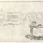
The troops are mounted; the castle is shown inside the ringed moat and a beautiful title cartouche with a miliary theme and descriptions are shown in the lower right corner….
Read More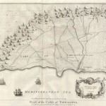
Depicted is the road to Barcelona, the road to Tortosa, and the towns of Valla, Constanina, Villa Secca, Cambrils, la Silva and others. Crosses are noted to indicate hills that…
Read More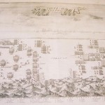
The print depicts the battle of Nieuport in 1660. A legend at the bottom of the print identifies the troops of the Dutch and English forces. Prince Frederick Henrik is…
Read More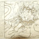
A very detailed battle map of the siege of Quesnoy, France by the Dutch on June 20, 1712. The birds-eye-view of the battle includes artillery tracks of the Dutch forces…
Read More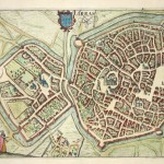
This hand colored copperplate engraving of the City of Arras, FRANCE is from Guicciardini’s publication Beschrijving van alle de Nederlanden. Good strong colors, the print is based on Braun &…
Read More