(Email us: map_help@maps-charts.com   or call toll free 1-888-513-MAPS)                                              May, 2013 

Click on the desired section below                    Foreign shipping additional – Please ask for quote

Mapping Instruments

Page 1 of 1

For Full View of Item – click on the image

70.00 Drawing Instrument Set, ca 1890


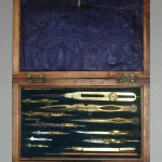
A twelve piece set of brass and steel drawing instruments with lift-out tray.   Top tray includes:   6 1/2" proportional dividers - with rack movement; 6 1/4" compass with 5 interchangeable tips, needle point pens; 2 pencils; 4 1/4" dividers; 3 1/2" dividers and compass w/3 interchangeable tips.  In the lower compartment there are two scales.  The set is complete and in Good condition.  The instruments are contained in a mahogany felt -lined box with brass inscription plate.  The locking device and key are missing.     ***SOLD***

70.01 Drawing Instrument Set, c1860


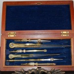
A very lovely velvet-lined mahogany case approximately 7 3/4" long , 3 3/4" wide and 1 1/4" high.   A silver name plate is noted on the lid.  A lift out tray contains six brass and steel instruments, including one with a 'dotting wheel'.  The six inch compass has a five leaf hinge.  In the lower compartment there is a six inch ebony color folding parallel rule with brass bars and studs as well as a six inch maple scale.  The set is complete and in very good condition, dating from the Civil War period.   ***SOLD***

70.02 Travel Compass, c1850


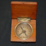
This unique pocket travel compass approximately 2 ' ' square in an oak box with a latching lid is in working condition.  The compass needle locks in place when the lid is closed thus permitting the user to open the lid to see the last point noted.  The compass points are in English and it's condition is very good [see our rating criteria on the Home Page].     ***SOLD*** 

70.03 Navigation Computer, ca 1951, by U. S. Coast & Geodetic Survey, Washington, D.C.


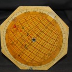
This instrument was used to scale distances on aeronautical charts in the 1950's.  It would also calculate air speeds based on miles as shown on the verso of the scale.  The instrument measures approximately (4.5" in diameter - hexagon shape) with movable rotating wheel on the front and verso.    $40.   ($9. shipping / handling / ins. - foreign postage addnl.)

70.04 Star Finder Scales, 1949, by Brownell & Weems, Annapolis, Maryland


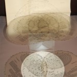
The Star Finder scale comes with 7 individual clear plastic scales that fit over the accompanying star chart.  Used by pilots in air navigation, the scale has a leather slip-jacket carrying case.  Over all measurement ( 8" diameter).  The star chart is folded as issued and is approximately (23.5" x 23.5').     $40.   ($9. shipping / handling / ins. - foreign postage addnl.)

Page 1 of 1

(Email us: map_help@maps-charts.com or call toll free 1-888-513-MAPS)

Home ] Age of Exploration ] Age of Exploration 2 ] Age of Exploration 3 ] Americas ] Americas 2 ] Asia-Australia ] Civil War ] Civil War 2 ] Civil War 3 ] Europe ] Europe 2 ] Europe 3 ] Globes & Map Gifts ] Battle Plan Maps ] Battle Plan Maps 2 ] [ Mapping Instruments ] Middle East & Africa Maps ] Braun & Hogenberg ] Political Cartoon Maps ] Rare Prints, Books & Catalogs ] Rare Prints & Books 2 ] Rare Prints & Books 3 ] World ] Original Art by Whistler ] Whistler Prints 2 ] Whistler Prints 3 ] Whistler Prints 4 ] Retail Outlet ] Currency Converter ] Order Form ] Hot Links ]

 
Web Design and Hosting By:
EKDesigns.com
Sign up for PayPal and start accepting credit card payments instantly. You are Visitor
Hit Counter

Cartographic Associates, LLC © 2013 All Rights Reserved