Antique Maps for Sale
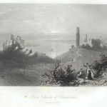
A long line of figures approaches the ruins with two gentlemen and their ladies in the foreground. The print is rated Very Good with only minor foxing outside the image…
Read More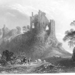
Two farmers with their sheep in the foreground with the castle looming above, sets the mood of this engraving. The print is rated Very Good with no apparent flaws and…
Read More
The publication presents the discovery and exploration of the North American continent; from the earliest references to the first settlements as described by the explorers themselves. There are 370 plates,…
Read More
A complete list of maps maintained in the Library of Congress. The collection lists maps from 1782 (the camps of le comte de Rochambeau) to 1900 (Map of the City…
Read More
Over 170 pages of colored maps plus a “pronouncing Index”, as well as geographical name index and abbreviations. This hard back edition is in very good condition, measures 11.0″ x…
Read More
The 110 page atlas contains data on the Soviet Union. Subjects include agriculture, fuel sources, weather, textiles, farming zones and petroleum reserves. Prepared by the Economist Intelligence Unit and the…
Read More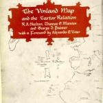
The book analyzes two documents that came to light in the late 1950’s. The first is a manuscript account of the expedition of Frair Carpini across Central Asia on a…
Read More
Rarely have the subject and style been so entertainingly fused as in this portrait of the incomparable, indomitable American painter James McNeill Whistler. Illustrated, hard back, 383 pages.
Read More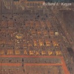
The publication focuses on cities and towns of South America to include Mexico City, Lima and Potosi. The volume, 235 pp has many full color illustrations; with it’s original dust…
Read More
Published by J. B. Lippincott Volume I, 316pp, captures the life of this famous American artist soon after his death in 1903. Pennell, one of Whistler’s admirers, provides an abundance…
Read More