Antique Maps for Sale
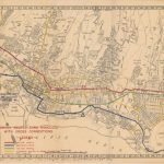
A very detailed map of the city that was issued in 1944 to show “two-way traffic, emergency routes, and alternate routes”. Off-limit areas, which were subsequently added to the printed…
Read More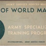
The Army Services Forces Manual (M-101) was specifically prepared for the use in the study of geography as part of the Army Specialized Training Program during WWII. There is 13…
Read More
The rise of Adolf Hitler and the formation of the Nazi Party after WWI; brought about the Third Reich. Every aspect of German life was flooded with Hitler’s image and…
Read More
A fascinating look back at Nazi Germany at a time when the United States was still neutral. Featured on the Time cover is Field Marshal Walther von Brauchitsch who commanded…
Read More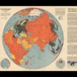
The map focuses on the largest “world island”, looking at the world continents of Europe, Asia, and Africa during World War II. It is color – coded to depict the…
Read More
Published by the Army Air Force (AAF), Washington, D. C. , 1944, scale 1:1,000,000; (23″ x 26″).
Read More
Published by the Army Air Force (AAF), Washington, D.C., 1944; scale 1:1,000,000 (32″ x 36″).
Read More
published by the U. S. Army Map Service, Washington, D. C. , 1944; 1:1,000,000 (27″ x 30″).
Read More
Published by the British Royal Air Force (RAF) CBI Far East , London, 1944 (33.1″ x 40.0). The map is one of a series of three and very rare, only…
Read More
published by the U. S. Army Map Service, Washington, D. C., 1944, scale 1:1,000,000 (22″ x 24″).
Read More