Antique Maps for Sale
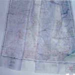
scale 1:2,000,000; published by the USAF, Aeronautical Chart Service, Washington, D.C.; December 1950 (42.0″ x 35.50″)
Read More
scale 1:2,000,000; published by the USAF, Aeronautical Chart Service, Washington, D.C.; January 1950 (39.50″ x 39.0″)
Read More
scale 1:2,000,000; published by the USAF, Aeronautical Chart Service, Washington, D.C.; March 1951 (39.50″ x 35.0″)
Read More
scale 1:2,000,000; published by the USAF, Aeronautical Chart Service, Washington, D.C.; 1951; (38.5″ x 39.0″)
Read More
scale 1:2,000,000; published by the USAF, Aeronautical Chart Service, Washington, D.C.; February 1951 (39.0″ x 38.0″)
Read More
scale 1:2,000,000; published by USAF, Aeronautical Chart Service, Washington, D.C. May 1951 (USC&GS)
Read More
scale 1:2,000,000; published by the USAF, Aeronautical Charts Service, Washington, D.C.; 1951; (35.0″ x 34.1″)
Read More
1:2,000,000; published by the USAF, Aeronautical Chart Service, Washington, D.C.; Sept. 1950; (37.0″ x 40.0″), printed by the U.S. Coast & Geodetic Survey
Read More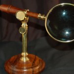
A fine reproduction of a 19th century magnifying glass (3 x) with a matching rosewood turned wood stand. The stand is adjustable, bronze fittings, permitting a set position for the…
Read More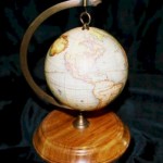
A companion stand for the Christmas globe. Fitted with a dual rod allows the globe to be suspended from the stand or hung on the tree. The rosewood base is…
Read More