Antique Maps for Sale
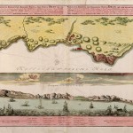
The top portion is a detailed 18th century map of Algeria (Oran Province) with Algeria noted and shaded relief features shown of the coast of the Mediterranean Sea. The bottom…
Read More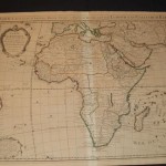
This is the third edition of this beautiful and very detailed map of Africa during the middle of the 18th century. It is an important map of the continent and…
Read More
An unusual folio sheet features four views of Cairo with its architecture and the busy Nile River. The views are flanked with French text describing the vicinity, commerce, and the…
Read More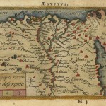
A miniature map of a portion of the Natoliae, quae olim Asia Minor, Nova Descriptio. The map depicts the Nile valley in great detail with numerous place names. In original…
Read More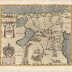
An unusually attractive map of Egypt with excellent color and graphic representation of the region. Filled with pictorial illustrations and embellishments to include an elaborate coat of arms and dedication…
Read More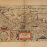
The map was first published in 1606 and this version appeared in Atlas Geographicke description of the Regions …. [Henry Hondius, 1636]. Embellished with a strapwork title cartouche in later…
Read More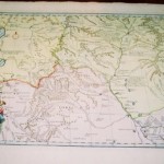
From d’Anville’s Nouvel Atlas de la Chine, the map covers part of central China and was published to accompany Du Halde’s Description Geographique, Historique, Chronologique, et Physique de l’Empire de…
Read More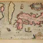
One of the earliest maps of Japan, and found in the atlases of Hondius, Mercator, and Jansson; this is a late 19th century reproduction of the famous map. Skillfully copied,…
Read More
This large map of Asia includes the islands of East Indies. The title indicates the map is based on cartography of De Lisle, with a similar treatment of Terra Yedo,…
Read More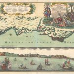
This splendid visual presentation typifies the style and format of a series of birds-eye-views and panoramic depictions of major cities and ports published in Germany during the eighteenth century. At…
Read More