Rare Prints, Books & Catalogs
Rare Old & Antique Maps for Sale.
Only 7 of the engravings remain in stock.
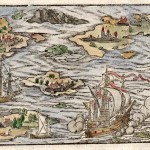
A detailed woodblock engraving from a group of leaves in Latin by Munster depicting a sea battle in original hand coloring. The engraving is rated Very Good [see our rating…
Read More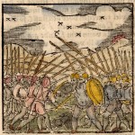
A striking woodblock engraving of a medieval battle scene contained on a full sheet of Latin text. The image measures (3.0″ x 2.9″) text the verso. In original hand coloring…
Read More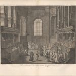
The engraving is one of the few visual records of an ordinary service at St. Paul’s Cathedral in London, in the early 18th century. The view shows the taking of…
Read More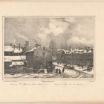
The print is by the famous French naturalist and artist Melbert. He spent 7 years in the United States traveling and recording his experiences as part of a scientific mission…
Read More
The print is by the famous French naturalist and artist, Milbert. He spent 7 years in the United States traveling and recording his experiences as part of a scientific mission…
Read More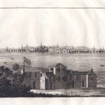
22.16 - Boston, Massachusetts, ca 1815, by Giulio Ferrario, Le Costume Ancien et Moderne, Paris
An unusual copperplate engraving showing Boston from Cattle William across the Charles River. The Boston Common, the State House, and numerous steeples can be seen in the city. In the…
Read More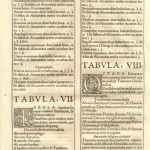
The text leaf is from the Strassburg edition of Ptolemy’s atlas edited by Laurent Fries. On the recto and verso is an introduction with each page and a 6-line initial….
Read More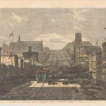
This unusual view of San Francisco in the mid 19th century shows a bustling street scene as a cable car moves up a hill. Large piles of goods line the…
Read More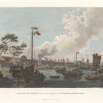
This engraving was made from a drawing by William Alexander, who accompanied the first British Embassy in China in 1792-94. This view appeared in the records of George Macartney’s travels…
Read More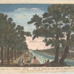
A beautiful view of the tree-lines path along the canal in St. James Park with a portion of Buckingham Palace in the background. Of note, this is a optical print…
Read More