World-Polar
Rare Old & Antique Maps for Sale.
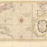
This is the Dutch edition (Van Schley) depicting the Atlantic Ocean. The chart is one of the earliest editions of the Atlantic basin that displays accurate information in beautiful detail…
Read More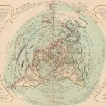
This rare copy of an unusual thematic map taken from the collection of Philippe Buache’s whose maps were purchased by J. A. Dezauche after Buache’s death; illustrates on a polar…
Read More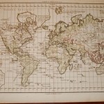
A beautiful map produced at the end of the 18th century reflecting the political boundaries of Europe affected by the various wars of the continent. Very detailed geographic data are…
Read More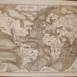
This is one of the earliest thematic maps of the world. Five years after Kircher’s death in 1680, another map of ocean circulation and tides was produced by Everard Werner…
Read More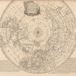
A very detailed map that shows the tracks of navigators in their numerous attempts to find a northern passage to the economic wealth of Aisla. The map depicts with track…
Read More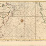
This is the Dutch edition (Van Schley) depicting the Southern Atlantic Ocean. The chart is one of the earliest editions of the Atlantic basin that displays accurate information in beautiful…
Read More