Middle East-Africa
Rare Old & Antique Maps for Sale.
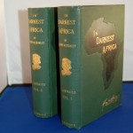
This is the two volume, 529pp & 472pp 1st American edition set, signed by the author, limited to 250 copies. The story of Henry Morton Stanley and Dr. Livingstone is…
Read More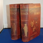
The publication discusses Stanley’s last African expedition. There are 50 woodcut illustrations, 3 foldout maps, 8 vo, original pictorial gilt, 529pp – 472pp. There are two woodcut frontispiece illustrations ………..
Read More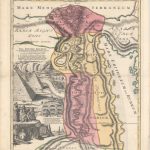
This is indeed a beautiful graphic map of Egypt, centered on the Nile River Valley. It covers the region from the Mediterranean to below the First Cataract at the confluence…
Read More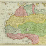
A beautiful 18th century map of northwestern Africa from Barbary, Nigeria and Guinea to below the equator. The map is full of geographic names and details with information on rivers…
Read More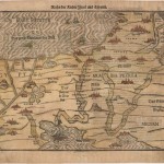
A dramatic woodblock map illustrating the routes taken by the Israelites in their Exodus from Egypt. The map is very graphic with illustrations of the Pharaoh drowning in the Red…
Read More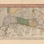
A beautiful and detailed map of the Barbary coast based on Gastaldi’s Africa. The map extends from Morocco to Libya on the western Mediterranean depicting the location of the Balearic…
Read More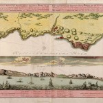
The top portion is a detailed 18th century map of Algeria (Oran Province) with Algeria noted and shaded relief features shown of the coast of the Mediterranean Sea. The bottom…
Read More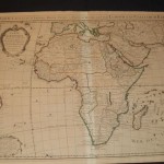
This is the third edition of this beautiful and very detailed map of Africa during the middle of the 18th century. It is an important map of the continent and…
Read More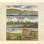
An unusual folio sheet features four views of Cairo with its architecture and the busy Nile River. The views are flanked with French text describing the vicinity, commerce, and the…
Read More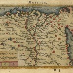
A miniature map of a portion of the Natoliae, quae olim Asia Minor, Nova Descriptio. The map depicts the Nile valley in great detail with numerous place names. In original…
Read More