Antique Maps for Sale
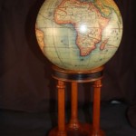
A fine reproduction of Robert de Vaugondy’s 1748 Globe Terrestre. The globe sits upon a three-legged elegantly finished rosewood stand. The globe and stand measure approximately (11.0″ x 5″.0″ –…
Read More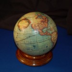
40.449 - Desk Top 6" Globe
A very nice detailed 18th century globe reproduction. The globe maker was Robert de Vaugondy of France. This faithful reproduction is dated 1745 and is an exact copy of the…
Read More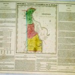
A detailed and very important statistical map of Delaware by the Carey & Lea Parisian publishers. The Atlas Gegraphique Statistque was first published in 1822 in Philadelphia. The map was…
Read More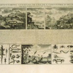
An interesting series of views of the Antilles to include natives of the region, amphibious creatures and insects as well as De I’le St Christophle, view of the fortifications; with…
Read More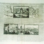
An unusual folio sheet with French text, two maps and four views. The Carte du Mexique shows Central Mexico and the Environs du Lac de Mexique highlighting the area near…
Read More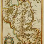
The map depicts present day County Carlow in Leinster Province and Catherlaugh which is now Carlow. The title is surrounded by a strapwork design cartouche topped with a caliper and…
Read More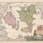
A beautiful engraved map of Denmark by Homann. The map shows the principal islands to include the eastern coastline of Denmark and a little of Sweden. Topographic detail identifies the…
Read More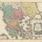
A densely detailed map that covers all of Greece, much of the Aegean Sea, and parts of Albania and Turkey. Large cities are shown as miniature birds-eye plans and smaller…
Read More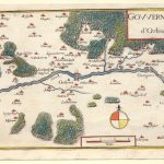
This small map from the 17th century was taken from an unknown publication. The map depicts the Loire River and the City of Orleans, France. Europe’s “30 year war” encompassed…
Read More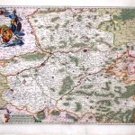
The map covers an area around the Belgian city of Mons on the southwest of Brussels to include northern France – Tournai, Charleroi, Maubeuge and Valenciennes. A very detailed figurative…
Read More