Antique Maps for Sale
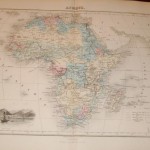
A decorative map from the Geographie Universelle Atlas, by Migeon. The map shows a view of Mount Saint Helene in the lower left corner. Engraved by Schroeder, 1870. Taken from…
Read More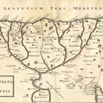
A detailed map of the Delta region of Egypt from a copperplate engraving prepared by J.B. Ghisti for publication as plate XXII Geogrphia Antiqua. Cellarius was a geographer and a…
Read More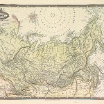
As with most of Garnier’s maps, the detail of this offering is most impressive. Taken from the Spherodidal & Universel de geographie, edited by Jules Renouard of Paris. The cartouche…
Read More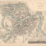
A very detailed plan of the city of St. Petersburg, Russia. Centered on the Peter and Paul Fortress, and located on the Zayachii Ostrov, Neva River. Good place name features…
Read More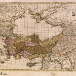
A detailed map centered on the Black Sea to include Turkey, Syria, Cyprus, and associated regions. In original outline color of the principal countries, the map is rated Very Good…
Read More
The map portrays the Eastern Mediterranean from Rome, through Asia Minor and the Holy Lands, to Babylon. The political divisions shown in color, depict the conditions of the first century…
Read More
Prior to the 3rd Reich and Nazi Germany, the National Forestry Service controlled the vast lands of Germany’s many forests. During the 3rd Reich, Hermann Goring was made head of…
Read More
The Mother’s Cross was first used in WW I as the war took a heavy toll on German men. As Nazi Germany began to evolve, Hitler took steps to insure…
Read More
The hat is worn by the Belgium security forces throughout the country. It bears the Royal Crown of Belgium and signifies their security symbol. The hat is new and indicates…
Read More
801.106 - Central Europe , World War II Newspaper, 1944, by New York Journal- American, New York
The newspaper New York Journal American in September 23, 1944 published on the back page map titled “Plan for Peaceful Germany Must Strip Prussia of Power”. The map shows a…
Read More