Americas
Rare Old & Antique Maps for Sale.
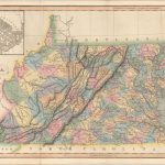
A detailed map of Virginia, Maryland and Delaware providing good topographical features of the region. Shown are settlements, buildings, roadways, and the Appalachian Mountain range. Includes an insert in the…
Read More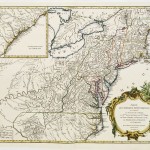
A very detailed engraving, extending the Mississippi and Illinois Rivers in the West and depicting the track of the Ohio River from its confluence with the Mississippi to its headwaters…
Read More
This map is centered on South America and includes nearly half of Africa, the southern portion of North America and the West Indies. Ocean currents are depicted and a very…
Read More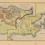
From Shaffner’s History of the United States, the map depicts the location of British forces and the French fornications of Louisburg during the French and Indian Wars. British forces had…
Read More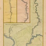
The map shows the routes of the Hamilton Expedition of 1778 -9 down the Miama and Wabash Rivers. The St. Vincent Boat Expedition and Fort Jefferson are also depicted. The…
Read More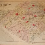
A very detailed map of the county showing city limits of Newburgh, Washington, Walden, Monroe and many others. Township boundaries, steam railroad lines, electric railroads, and roadways are among the…
Read More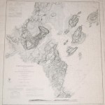
The first published nautical chart by the Survey of the Coast (U.S. Coast Survey) to include both hydrographic and topographic information. In addition to the soundings in the harbor there…
Read More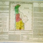
A detailed and very important statistical map of Delaware by the Carey & Lea Parisian publishers. The Atlas Gegraphique Statistque was first published in 1822 in Philadelphia. The map was…
Read More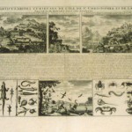
An interesting series of views of the Antilles to include natives of the region, amphibious creatures and insects as well as De I’le St Christophle, view of the fortifications; with…
Read More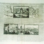
An unusual folio sheet with French text, two maps and four views. The Carte du Mexique shows Central Mexico and the Environs du Lac de Mexique highlighting the area near…
Read More