Americas
Rare Old & Antique Maps for Sale.
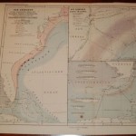
A sheet containing three maps to include the East Coast of the United States from Massachusetts to Florida and depicting the Gulf Stream. The second map shows Long Island and…
Read More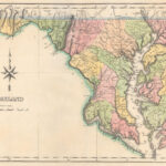
The map is on a full sheet (20.6″ x 16.5″) with text below describing boundaries, principal towns, cities, climate, and other geographic detail. Maryland counties are shown in color. Rivers…
Read More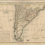
A large, finely engraved map of the southern part of South America with good topographic detail and place names throughout the map. Included are track lines of several explorations including…
Read More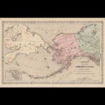
This is one of the earliest atlas maps to show Alaska as a United States possession. It covers a wide geographic area from Great Bear Lake in northern Canada west…
Read More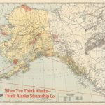
The map was published by the Alaska Steamship Company and features its colorful logo at the lower left corner. The detailed topographic features include Mt. McKinley National Park, most major…
Read More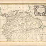
This uncommon and finely engraved map covers the region known as Tierra Firma (Columbia & Venezuela), the Dutch, Portuguese, and French colonies of Guyana; as well as parts of Peru…
Read More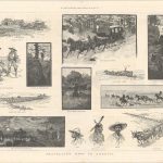
Published in the April 16, 1887 edition of The Illustrated London News, the issue included a group of images “bull-whacker” and “mule-skinner”. Graphic images also include a corpse hanging from…
Read More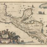
Arnoldus Montanus (1625 – 1683) produced one of the greatest illustrated books on the Americas De Nieuwe en Onbekende Wereld, 1671. There were one hundred beautifully engraved plates, views, and…
Read More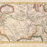
A very fine map of Louisiana and of northern and western Florida showing the French claims west of the Appalachians. From about 1650 to the middle of the eighteenth century,…
Read More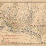
A very detailed map of the city that was issued in 1944 to show “two-way traffic, emergency routes, and alternate routes”. Off-limit areas, which were subsequently added to the printed…
Read More