Antique Maps for Sale
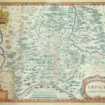
A copperplate engraving in original color with a blank cartouche at the lower left. This map, with van den Keere’s signature; first appeared in Jansson’s Atlas Maioris Appendix of 1630….
Read More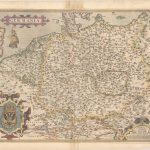
An elegant map of the German Empire which, at the time, included the Netherlands and Belgium tretching from Calais to the Wista River in present day Poland, and south to…
Read More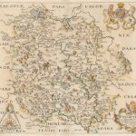
Christopher Saxton became known as the ‘father of English cartography’. During his career he carried out extensive surveys of England and Wales between 1573 and 1578. This map of the…
Read More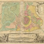
A beautiful map of old Vienna with fortifications and surrounding suburbs depicted in original color. A panoramic birds-eye view of the city adds to the grandeur of the map. The…
Read More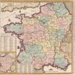
This beautifully engraved map of France shows the country divided into 16 provinces. A legend at top left identifies parliaments, universities, miliary facilities, Roman antiquities, and the locations of battles…
Read More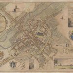
A beautifully engraved plan of Canterbury, laid out in grid form, showing streets, city walls, gates, buildings, parks and alike. The Cathedral, St. Augustine’s Monastery, St. George Priory, and the…
Read More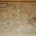
A detailed map of Languedoc in southern France; the region around Montpellier. The map is in full original color with the title cartouche uncolored. Allard, an engraver / publisher produced…
Read More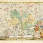
A wonderful map by Homann of Erfurt in the Thuringia region of east central Germany. Taken from the Grosser Atlas, a panoramic view of the city of Erfurt extends across…
Read More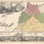
A Magnificat map in the true appeal of Homann family cartography. This very large and graphic map shows the domains of tribes of the region. The map includes the Canary…
Read More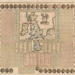
From the Atlas Historique this is an intriguing cartographic rendering. Depicting Britain under Roman rule, the map with abundant text about the history of Britain, including tables, concerning the kings,…
Read More