Europe
Rare Old & Antique Maps for Sale.
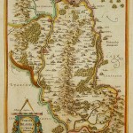
The map depicts present day County Carlow in Leinster Province and Catherlaugh which is now Carlow. The title is surrounded by a strapwork design cartouche topped with a caliper and…
Read More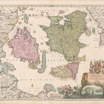
A beautiful engraved map of Denmark by Homann. The map shows the principal islands to include the eastern coastline of Denmark and a little of Sweden. Topographic detail identifies the…
Read More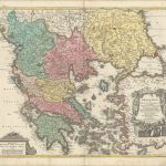
A densely detailed map that covers all of Greece, much of the Aegean Sea, and parts of Albania and Turkey. Large cities are shown as miniature birds-eye plans and smaller…
Read More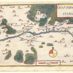
This small map from the 17th century was taken from an unknown publication. The map depicts the Loire River and the City of Orleans, France. Europe’s “30 year war” encompassed…
Read More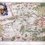
The map covers an area around the Belgian city of Mons on the southwest of Brussels to include northern France – Tournai, Charleroi, Maubeuge and Valenciennes. A very detailed figurative…
Read More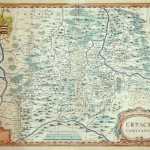
A copperplate engraving in original color with a blank cartouche at the lower left. This map, with van den Keere’s signature; first appeared in Jansson’s Atlas Maioris Appendix of 1630….
Read More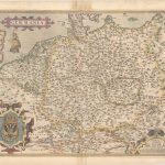
An elegant map of the German Empire which, at the time, included the Netherlands and Belgium tretching from Calais to the Wista River in present day Poland, and south to…
Read More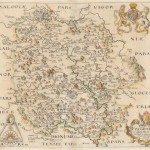
Christopher Saxton became known as the ‘father of English cartography’. During his career he carried out extensive surveys of England and Wales between 1573 and 1578. This map of the…
Read More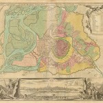
A beautiful map of old Vienna with fortifications and surrounding suburbs depicted in original color. A panoramic birds-eye view of the city adds to the grandeur of the map. The…
Read More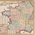
This beautifully engraved map of France shows the country divided into 16 provinces. A legend at top left identifies parliaments, universities, miliary facilities, Roman antiquities, and the locations of battles…
Read More